
Pearl River Revitalization Plan
The Pearl River Revitalization Project reconnects Jackson to the Pearl River through new public access points, integrated park and trail networks, and ecological flood management strategies.
-
The Pearl River Revitalization Plan was developed by the Pearl River Revitalization Coalition in collaboration with TREE Urban Design + Landscape Architecture and project partners. It builds upon the Alternative D1 flood control framework proposed by Mendrop Engineering and the Rankin-Hinds Flood Control District and presented by the U.S. Army Corps of Engineers.
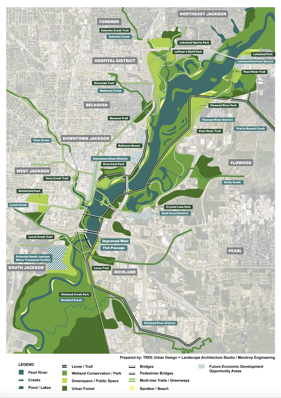
TREE’s role has focused on translating the D1 flood control footprint into a comprehensive, multi-layered river corridor vision that integrates flood protection with public space, landscape systems, and long-term urban development. The plan reframes the riverfront as both essential infrastructure and a shared civic landscape, organizing the corridor into interconnected zones for recreation, habitat restoration, and future development while balancing ecological performance with public access.
A central component of the framework is a connected network of parks, trails, and greenways that link the Pearl River to surrounding neighborhoods through existing creek systems. These corridors expand access to the river by foot and bicycle while incorporating green infrastructure that filters and detains stormwater before it enters the Pearl River, improving water quality and strengthening ecological function.
The plan is illustrated across multiple scales to communicate both regional impact and site-specific opportunity:
Regional Flood Control Framework: approximately 1,500 acres
Downtown Jackson Focus Area: approximately 500 acres
Riverfront Park Concept: a 150-acre public landscape envisioned atop a capped former landfill
-
2023 - Ongoing
-
1500 Acres
-
Jackson, Mississippi | Pearl River Basin
-
Landscape Architecture and Urban Planning - TREE Urban Design Studio
Engineering - Mendrop Engineering
Technical Oversight - U.S. Army Corps of Engineers
Pearl River Revitalization Coalition Members - City of Jackson, Hinds County, Greater Jackson Chamber of Commerce, Downtown Jackson Partners, University of Mississippi Medical Center, Jackson State University, Tougaloo College, Millsaps College, Mississippi College, Belhaven University, Hinds Community College, Greater Belhaven Foundation, Great City Mississippi Foundation, Jackson Heart Foundation, Fondren Renaissance Foundation, Visit Jackson, Mississippi Children’s Museum, Mississippi Museum of Art, C Spire Foundation, Jackson Medical Mall Foundation, Ergon Foundation, LeFleur East Foundation, Clean Up Jackson
Pearl River Revitalization: A Plan for to Connect the City to the River
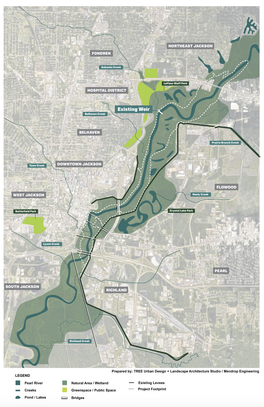
Though historically separated from the Pearl River, Jackson was founded along the river at what is now known as LeFleur’s Bluff. The Pearl River Revitalization Plan repositions the river as a central civic and ecological asset by integrating flood resilience, public access, and landscape systems along the river corridor.
Developed within the U.S. Army Corps of Engineers’ proposed Alternative D1 boundary, the plan advances a modern approach to flood management that pairs infrastructure improvements with park and trail networks, ecological stormwater systems, and restored floodplain landscapes. Constructed wetlands, green infrastructure, and nature-based flood strategies work together to reduce flood risk while expanding access to the river and strengthening connections between surrounding neighborhoods.
Beyond flood protection, the project establishes a long-term framework for public space, recreation, and environmental stewardship along the Pearl River. By reconnecting communities to the river through trails, parks, and resilient landscapes, the plan supports Downtown Jackson and the broader metro area while promoting a shared identity rooted in the region’s natural systems.
Existing Riverfront Condition
For decades, the communities surrounding the Pearl River have experienced the unfortunate effects of outdated stormwater management infrastructure. The existing conditions of the Pearl River present significant challenges. Pollution from sewage leakage and litter is prevalent, exacerbated by the poor condition of water treatment facilities and lack of ecological systems. Access to the river is severely limited from the city and surrounding areas, further hindering efforts to manage and improve its condition. Despite the existing limitations, The US Army Corps of Engineers have developed a proposed plan for the Pearl River Basin, Alternative D1, which offers a unique opportunity to reimagine Jackson’s riverfront.

The Pearl River Revitalization Plan presents a comprehensive vision for an ongoing initiative focused on sustainable flood control measures while enhancing public amenities and long-term resilience for the Pearl River Basin and surroundings regions.
In 2024, over 20 local business owners, community leaders, engineers, government entities, and others have now joined together to develop the Pearl River Revitalization Coalition to advocate for the flood control solution offering the best alternative for lasting flood protection and benefits for future generations.

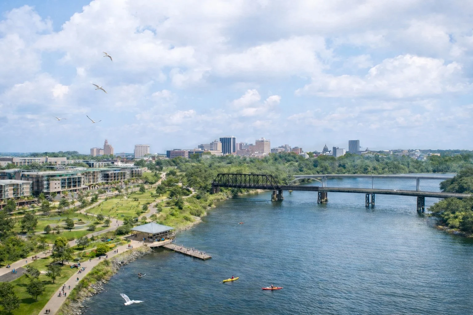
Riverfront Jackson Downtown District
Riverfront Jackson represents a generational opportunity to reconnect the city to the Pearl River and redefine Downtown’s eastern edge. For decades, the river has functioned as both a natural asset and a physical barrier. With the advancement of the approved flood mitigation framework, the corridor can now evolve from vulnerable edge condition into resilient civic infrastructure. TREE Urban Design is working to shape a riverfront that integrates flood protection, ecological restoration, public access, and long term economic development, transforming the Pearl from a threat into Jackson’s defining public landscape.
The River District extends beyond park space to imagine a walkable, mixed-use neighborhood anchored by the new riverfront. By aligning public investment in flood protection and open space with strategic private development sites, the district creates a framework for housing, economic growth, hospitality, and cultural destinations along the water’s edge. This is an economic development strategy that leverages landscape infrastructure to attract residents and reinvestment back to the urban core.