
Strategic Framework Plan for Parks & Trails
A study identifying top catalyst park and trail projects across that city that have ability to create high impact for communities.
-
The Strategic Framework Plan for Parks & Trails identifies 20 catalyst park and trail projects with the ability to create high impact for communities throughout the City of Jackson. The research was showcased at the 2024 Jackson Design Forum and provided an opportunity to talk about future parks and trails across the city. Tree developed the research, analysis, and curated the public engagement event bringing together government, non-profit, and business leaders.
While developing the Strategic Framework Plan for Parks and Trails, we used 12 city-scale maps to analyze and evaluate where park and trail projects can have the greatest impact in Jackson. The maps measured characteristics like:
Urbanization Patterns (urban walkability vs suburban car-oriented)
Population Density
Employment Centers
Commercial Districts
Food Access and Food Deserts
Learning Institutions and Resources
Residential Neighborhoods
Public Land Ownership
Vacant or Underutilized Properties
Stakeholders and Geography
Public Safety
Environmental Challenges (urban flooding or urban heat island)
Combined, the maps create an evaluation matrix that determines where to place catalyst park and trail projects. From the map series, we developed a “Composite Map” that shows how all the layers overlap and spatially connect. This planning process is referred to as the “McHarg Method” which is a landscape architecture process that involves creating a graphic model of an area and using it to identify the best possible options for development. Ian McHarg created this planning process in the 1960s when he published Design with Nature to bring a more analytical and ecological approach to urban planning.
-
2023 - Ongoing
-
City
-
Jackson, Mississippi
-
Project Partners: Great City Mississippi Foundation
Landscape Architecture and Urban Planning: Travis Crabtree PLA
Photography: Imani Khayyam
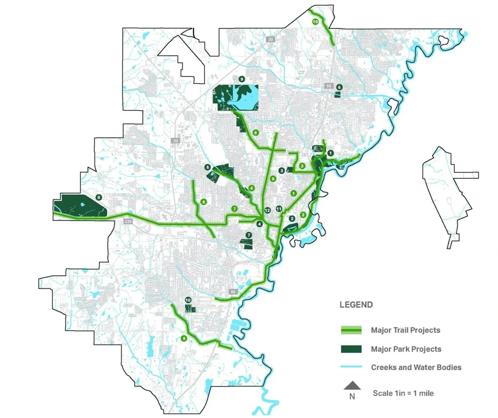

The Strategic Framework Plan was developed based on a city-scale analysis and evaluation matrix that measured a range of factors
The factors included current parks and trails, urbanization, access to resources, publicly owned land, vacant and blighted property, demographics, stakeholders, safety, and environmental challenges like urban flooding and heat island effect. The layers were superimposed into on “composite map” to determine target areas for new catalyst projects.


The 2024 Design Forum for Parks and Trails provided an opportunity to bring 14 presenters together to discuss citywide catalyst projects.
Presenters shared their projects in the form of a presentation, design charrette, or workshop. The data collected from the forum influenced the Strategic Framework Plan for Parks and Trails.


